Monday, May 10, 2010

NLS Maps API: historical map of Great Britain for mashups

With the help of the software developed in our project OldMapsOnline.org has prepared a very interesting historical mapping application, allowing anyone to include selected historical geo-referenced maps of Great Britain in their own websites. Sets of Ordnance Survey mapping relating to Scotland, England and Wales, dating from the 1920s to 1940s, have been seamed together and geo-referenced, then specially prepared for use in external websites.

NLS Maps API: Historical maps of Great Britain for use in mashups 

For more information, please view http://geo.nls.uk/maps/api/

The maps have been made available under a Creative Commons Attribution Licence, allowing free use and adaptation of the mapping, provided it is properly attributed. The maps were scanned and geo-referenced by the National Library of Scotland, and rendered on the Amazon EC2 computer
cluster by Klokan Technologies GmbH, with a software based on a customised version of the MapTiler application.

The maps can be used for many purposes - they can be integrated with other mapping, used for research purposes, used as a backdrop for bespoke markers or mapping data, or used to create other maps (such as OpenStreetMap). The application will also run on many mobile devices, including the iPhone, iPad or Google Android based phones - simply by opening the website http://nls.tileserver.com/.

The historical map API homepage provides simple instructions for how to embed the mapping in websites, and use it with the most popular free web-mapping services, including Google, Bing, and Openlayers.

OldMapsOnline.org project will include this map as one of the reference maps in our Georeferencer.org online service.

More info at http://geo.nls.uk/maps/api/

Monday, January 18, 2010

Meet us at the ICA CartoHeritage Workshop in Vienna!


The ICA Commission on Digital Technologies in Cartographic Heritage and Vienna University of Technology are organising the 5th International Workshop on Digital Approaches in Cartographic Heritage in Vienna on February 22–24, 2010.

We will give a talk OldMapsOnline.org: IIPImage, JPEG2000 and Georeferencer.org during this workshop.

Please follow direct link to the registration form if you are interested to participate.

We look forward to discuss our project and related topics with the attendees of this workshop!

Wednesday, January 13, 2010

IIPImage JPEG2000: Free Software for Zoomable High Resolution Online Images!

Moravian Library and the OldMapsOnline.org project are proud to announce the release of a new version of the open-source IIPImage server software (http://help.oldmapsonline.org/jpeg2000/).

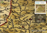
The freely available IIPImage software can be used for stunning online presentations of scanned documents, paintings, maps, books, newspapers, photographs or other high-resolution images on the web directly from JPEG2000 or TIFF files.

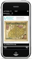
The new version allows direct publishing from JPEG2000 images to a wide variety of different client technologies based on AJAX, Adobe Flash or Silverlight. These include popular pan&zoom viewers based on Zoomify or Seadragon technology (including the Seadragon AJAX viewer and the Seadragon iPhone application) as well as it's own AJAX enabled IIPMooViewer. The documents provided by IIPImage can be displayed in any web browser and on a number of platforms - Windows, Mac, Linux or iPhone.

The software is primarily targeted at institutions who operate their own server connected to the Internet and who want to publish large collections of digital images directly from JPEG2000 or
TIFF files.

Institutions who does not have the necessary infrastructure can follow our alternative tutorial at http://help.oldmapsonline.org/publish/ on how to achieve the same using standard web hosting and free software.

IIPImage is a light-weight client-server system for fast and efficient online viewing and zooming of ultra high-resolution images. It is designed to be bandwidth and memory efficient and usable over a slow Internet connection even on gigapixel sized images.
It is available for free, under an open source license (GNU GPL). We recommend installing
the software on a Linux (or other UNIX) server. We have prepared an easy to install binary package for Debian and Ubuntu with step-by-step instructions for installation.

JPEG2000 support has been implemented using the Kakadu library, which provides one of the fastest implementations of the JPEG2000 ISO standard and is redistributable for non-commercial use.

The enhancement of IIPImage was developed by the Moravian Library and the OldMapsOnline.org project with the support of grants from the Ministry of Culture of the Czech Republic.

The Moravian Library (http://www.mzk.cz/), based in Brno, Czech Republic, is a research institution and a legal deposit library. Project OldMapsOnline.org (http://www.oldmapsonline.org/) is a research project of the Moravian Library that aims to develop software to assist in the management, manipulation and visualisation of historical map collections on the web. The project team is designing online tools for publishing, collaborative georeferencing, annotation, 3D visualisation, accuracy analysis and geometadata specification for old maps.

For more information and for the IIPImage JPEG2000 software, see http://help.oldmapsonline.org/jpeg2000/.

Saturday, October 24, 2009

Workshop in Scotland (BCS Map Curators' Group)


OldMapsOnline.org workflow was presented during a Workshop organized by The Map Curators' Group of the British Cartographic Society.
The title of the workshop was "From paper to screen: Putting maps on the web".

Details about this workshop are available online at the BCS website, including a programme with several interesting presentations related to the subject.

The morning session of the second day of the workshop was devoted to a practical demonstration where Christopher Fleet (National Library of Scotland) and Klokan Petr Pridal (Moravian Library Brno, OldMapsOnline.org) used Bartholomew 1912 map of Edinburgh to present a complete old map processing workflow starting from scanning, over online publishing and georeferencing, to the visualization on the web by overlaying of Google Maps and Google Earth.

Here are the slides from the workshop:

From paper to screen: Putting maps on the web

The online map presentations created during the workshop:


  1. Zoomify presentation of the scan of the paper map.
  2. Google Maps overlay generated by MapTiler from the georeferenced image.
  3. OpenLayers viewer generated by MapTiler from the georeferenced image.


You can also download the original files for this map and try the suggested workflow yourself:


  • The file as it was produced by the scanner: 74400474.tif (!!! big: 200+ MBytes - use right click and "Save as")
  • The georeferenced image: 74400474-geo.tif (!!! big: 200+ MBytes - use right click and "Save as")


A step by step tutorial for publishing with Zoomify and MapTiler is available on on our website:
http://help.oldmapsonline.org/publish/

Tuesday, July 21, 2009

Poster at ICHC 2009

ICHC 2009 - International Conference on the History of Cartography was this year in Copenhagen, Denmark - July 12th - 17th.

Historians and librarians, map curators and people from all around the world who knows each other from discussions at the maphist@, who works at the The History of Cartography Project and who are behind the collections and activities linked from the website http://www.maphistory.info/ had a chance to meet there face to face.

I presented at this conference a poster (PDF) describing our software tools and workflow we are working on, with screenshots of the latest prototypes.
I also made a short demo at the ISCEM meeting (International Society of the Curators of the Early Maps).

This was the first public presentation of the online tools, which are under heavy development now. I also made a report about the development of the open-source image server for JPEG2000 files based on IIPImage, which we are going to publish soon.

Wednesday, June 10, 2009

ELAG: Workflow for old maps in libraries

At the European Library Automation Group (ELAG) conference we discussed the comprehensive workflow which we recommend for rare maps publishing in libraries.
The final summarizing presentation is attached to this blog post.


Detailed notes and links to software tools and online prototypes are available at our support website: http://help.oldmapsonline.org/.

Monday, May 25, 2009

MapTiler: Desktop application for map online publishing from GIS tools

We actively contributed to the development of the MapTiler application, which is an excellent tool for fast and easy to use publishing of any existing raster maps, which are already georeferenced with GIS tools.
MapTiler runs under Windows, MacOSX and Linux. It is a desktop application which loads your existing geodata in formats such as GeoTIFF, JPEG2000 (GeoJP2), ECW, MrSID, HFA, BSB etc. It then generates tiles which are compatible with Google Maps, OpenStreetMap, Yahoo Maps, Microsoft Live (Bing) etc. Resulting maps based on your geodata can overlay these base maps and online visitors can compare them by changing the transparency in the webviewer supplied as part of the output.

To publish your maps you don't need to setup anything special on your webserver, just copy the automatically generated files (JPEG tiles and HTML based webviewers). The form of the publishing is similar to Zoomify tiles, but your georeferenced maps are correctly transformed from the original coordinate system into a Mercator projection used in popular web applications.

We presented the MapTiler application at the ICA Fourth International Workshop: Digital Approaches to Cartographic Heritage in Venice, Italy 6 – 7 April 2009


More info at http://www.maptiler.org/.


In case you are not using any GIS tools in your library yet you probably should not process the maps with MapTiler. We are working on online tools which would allow you to georeference your maps and generate map overlays a la MapTiler from your scans using only a web browser.


On the other hand, if you already use GIS application for georeferencing, then MapTiler is very practical tool for quick and easy publishing your old map on the Internet. Some old maps were published with MapTiler in the National Library of Scotland or in Spain in Malgrat de Mar city council as well as in Czech Republic in Olomouc (Olomouc Bastion 1842, Bohemia and Moravia from 1910).