We would like to give advanced notice to all our users that the infrastructure that our sites and services run on is being upgraded. This is essential maintenance and whilst it is happening Old Maps Online will be partially, and at times may be completely, unavailable.
This will occur on Saturday 17th January 2015 between 10 am and 5 pm (Central European Time).
We apologise for any inconvenience caused.

Showing posts with label Old Maps Online. Show all posts
Showing posts with label Old Maps Online. Show all posts
Friday, December 19, 2014


Wednesday, March 5, 2014
Impact video now available

As part of the Jisc funding requirements the Old Maps Online team had to produce a video report on the impacts of the website. As the site launched early on in the life of the project there was plenty of material for inclusion in the video and lots of people willing to talk about why they like the site.
The filming was done on location at the one-day conference, Working Digitally with Historical Maps, that we organised in Edinburgh in December 2013 and we are grateful to the National Library of Scotland for allowing this. The video has been uploaded onto and is available to view on the new "Impacts" page on the website.
Wednesday, September 18, 2013
Old Maps Online at the International Cartographic Conference
Despite the funding from Jisc finishing in January this year we are still working to promote the project. Petr Přidal of Klokan Technologies recently presented a poster at the International Cartographic Conference, which this year was held in Dresden, Germany from the 25th -30th August. The poster presentation focused on the Old Maps Online project as a search system tailored to work with historical maps in a spatial way, something traditional search engines struggle with, and how implementing Georeferencer as a means to turn scanned maps into digital resources which are easy to find using crowd-sourcing helped various national libraries contribute their maps to the Old Maps Online system.


Monday, April 22, 2013
Preserved for posterity
Old Maps Online has been included on a list of 100 websites considered important enough to preserve for future generations. Experts from a consortium of UK national libraries chose 100 Websites which they consider will be essential reading for those looking back at 2013. An archive of these UK based websites will be created using new powers the libraries have been given to preserve digital content.
 The eclectic mix of sites on the list range from social media such as facbook and ebay, via online shopping from high street stores to housing and public interest sites such as OpenStreetMap and Galaxy Zoo. Old Maps Online is described as:
"...revolutionising the way in which we conduct historical research and will be invaluable for future researchers wishing to dive through layers of history geographically"
The project team is immensely proud to have been included in this list.
The eclectic mix of sites on the list range from social media such as facbook and ebay, via online shopping from high street stores to housing and public interest sites such as OpenStreetMap and Galaxy Zoo. Old Maps Online is described as:"...revolutionising the way in which we conduct historical research and will be invaluable for future researchers wishing to dive through layers of history geographically"
The project team is immensely proud to have been included in this list.
Tuesday, January 8, 2013
Edinburgh Conference: Working Digitally with Historical Maps
Firstly we'd like to wish all our readers a Happy New Year. Secondly below you will find a summary of the proceedings of the one day conference organised by the Old Maps Online team which was held at the end of 2012.
The day was broken in gently at 10am with coffee and an introductory welcome. This was followed by Petr Pridal giving the key note presentation detailing the improved functionality and searching and much extended content of our own Old Maps Online site (we'll let you know when these changes have actually gone live).
Following that Session 1 looked at using technology to map
 |
| Detail from Nairn and Elgin, W. Johnson, 1832. (c) Cartography Associates |
 |
| Detail from Scotland SE, E. Stanford , 1901. (c) Cartography Associates |
 |
| Name detail on the Eye Peninsula of Lewis in the Outer Hebrides from the OS of Scotland, Popular Edition, Stornoway, 1925, from A Vision of Britain through Time |
We'd like to say a big thank-you to everyone for taking the time to come to the conference, as despite being held in the run up to Christmas it was well attended. Everyone I spoke to during and after the day seemed to enjoy it. We have created a webpage about the conference, it gives the names of the speakers, titles, abstracts and website addresses for all papers plus downloadable PDF copies of both the programme and abstracts.
There is now also a similar page giving information about the previous Working Digitally with Historical Maps conference held in February 2012 at the New York Public Library which launched the initial Old Maps Online website, see here.
Monday, November 26, 2012
AHRC Digital Transformations Moot
Last Monday the project attended the AHRC-moot on Digital Transformations, held at the Mermaid Conference Centre in London. Humphrey Southall represented Old Maps Online and presented a joint display entitled 'Old Maps and the Spatial turn'. Alongside Old Maps Online, this exhibition included Kate Jones (University of Portsmouth) who was introducing the new Bomb Sight website/mobile app (another JISC funded project), Kimberly Kowal (British Library and a member of our steering group) who presented the BL Georeferencer project on which they collaborated with Klokan Technologies and Leif Isaksen (University of Southampton) who was presenting the Pelagios project which links together resources about the ancient world via a gazetteer of ancient places and YAMA a historical map annotator. There was also a display about the Georeferencer Metadata Hub from Klokan.
 |
| copyright © 2000 Cartography Associates. |
For further information about the day, including a downloadable PDF of the programme see the AHRC website: http://www.ahrc.ac.uk/Funding-Opportunities/Research-funding/Themes/Digital-Transformations/Pages/Digital-Transformations-Moot.aspx
Monday, November 12, 2012
Focus on the Collections: The National Library of Scotland
The next
in our series of more in-depth posts about particular collections is focused on
the National Library of Scotland's map collection.
The first thing to note about this library is that
it has the largest selection of on-line digital maps in the UK with over 44,000
accessible high-resolution images within an online map library in the
"Digital resources" section of their institutional website. Of course
this is only a small proportion in terms of their total collection of paper
maps, but none-the-less this quantity of digital images is in itself a
substantial achievement in the digital archives world and identifies the National Library of Scotland
as a leading-light in this digital community. The majority of the collection is
understandably focussed on Scotland, although there are maps covering the whole
of Great Britain included as well.
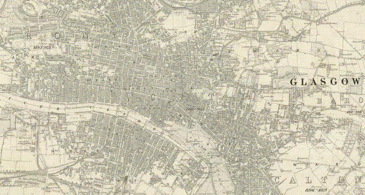 |
| (c) National Library of Scotland |
The Library
offers the user the option to purchase digital images or printouts of its
online maps from them, something many users appreciate. More than this though
this library offers the user different ways in which they can browse and access
their maps through a range of cutting-edge map technologies. These include a
zoomable maps and gazetteer viewer, KlokanTechnologies Georeferencer software allowing users to help add
co-ordinates to yet more maps (more on this in
the British Library post), a historical maps API which
allows users to incorporate material from the Library into their own websites, overlay technology which lets users place old maps on top of
new ones, a project which provides mapping tools for historians and of course they
also participate in our Old Maps Online project. This extensive repertoire
of software applications highlights the commitment of the National Library of
Scotland to making their map material available to users in new and interesting
ways.
With thanks to Chris Fleet, Senior Map Curator at the
National Library of Scotland, for his assistance with this post
National Library of Scotland, for his assistance with this post
Friday, November 2, 2012
Old Maps Online - so what?


First and foremost we think we have achieved what we set out to do: creating an online search facility which is easy to use, is full of useful content and links to a wide variety of host institutions. There are a number of different ways we consider the project unique in its success;
- We have created and implemented new MapRank Search software suitable for hosting material from a myriad of institutions
- We have persuaded a range of different digital map libraries from around the world to participate
- We have included maps covering all parts of the whole world
- We have helped some UK libraries add geographical metadata to their digital map images
- We have encouraged all libraries holding maps to think about their metadata in a geographical context
- We have provided a single entry point for searching maps of the same geographical location without the need to know which library holds the actual map
- We have clustered metadata for use in a new way
However, we feel that even more than that we have started to influence how libraries think about their geographical holdings. Institutions are beginning to consider how geographical content within their collections can best be made findable and searchable. They are raising questions about the best way to make this content available to their users. Many more institutions have contacted us than are currently contributing saying they would have liked to participate, but that their material as yet does not have a geographical element to its metadata and unfortunately for both them and us it will not be added in time to be included before the end of the current funding for Old Maps Online.
We have proposed a concept and proved it works -- but this is just one way in which enriched metadata can be used in new ways to simplify online searching.
Subscribe to:
Posts (Atom)