Saturday, October 24, 2009

Workshop in Scotland (BCS Map Curators' Group)


OldMapsOnline.org workflow was presented during a Workshop organized by The Map Curators' Group of the British Cartographic Society.
The title of the workshop was "From paper to screen: Putting maps on the web".

Details about this workshop are available online at the BCS website, including a programme with several interesting presentations related to the subject.

The morning session of the second day of the workshop was devoted to a practical demonstration where Christopher Fleet (National Library of Scotland) and Klokan Petr Pridal (Moravian Library Brno, OldMapsOnline.org) used Bartholomew 1912 map of Edinburgh to present a complete old map processing workflow starting from scanning, over online publishing and georeferencing, to the visualization on the web by overlaying of Google Maps and Google Earth.

Here are the slides from the workshop:

From paper to screen: Putting maps on the web

The online map presentations created during the workshop:


  1. Zoomify presentation of the scan of the paper map.
  2. Google Maps overlay generated by MapTiler from the georeferenced image.
  3. OpenLayers viewer generated by MapTiler from the georeferenced image.


You can also download the original files for this map and try the suggested workflow yourself:


  • The file as it was produced by the scanner: 74400474.tif (!!! big: 200+ MBytes - use right click and "Save as")
  • The georeferenced image: 74400474-geo.tif (!!! big: 200+ MBytes - use right click and "Save as")


A step by step tutorial for publishing with Zoomify and MapTiler is available on on our website:
http://help.oldmapsonline.org/publish/

Tuesday, July 21, 2009

Poster at ICHC 2009

ICHC 2009 - International Conference on the History of Cartography was this year in Copenhagen, Denmark - July 12th - 17th.

Historians and librarians, map curators and people from all around the world who knows each other from discussions at the maphist@, who works at the The History of Cartography Project and who are behind the collections and activities linked from the website http://www.maphistory.info/ had a chance to meet there face to face.

I presented at this conference a poster (PDF) describing our software tools and workflow we are working on, with screenshots of the latest prototypes.
I also made a short demo at the ISCEM meeting (International Society of the Curators of the Early Maps).

This was the first public presentation of the online tools, which are under heavy development now. I also made a report about the development of the open-source image server for JPEG2000 files based on IIPImage, which we are going to publish soon.

Wednesday, June 10, 2009

ELAG: Workflow for old maps in libraries

At the European Library Automation Group (ELAG) conference we discussed the comprehensive workflow which we recommend for rare maps publishing in libraries.
The final summarizing presentation is attached to this blog post.


Detailed notes and links to software tools and online prototypes are available at our support website: http://help.oldmapsonline.org/.

Monday, May 25, 2009

MapTiler: Desktop application for map online publishing from GIS tools

We actively contributed to the development of the MapTiler application, which is an excellent tool for fast and easy to use publishing of any existing raster maps, which are already georeferenced with GIS tools.
MapTiler runs under Windows, MacOSX and Linux. It is a desktop application which loads your existing geodata in formats such as GeoTIFF, JPEG2000 (GeoJP2), ECW, MrSID, HFA, BSB etc. It then generates tiles which are compatible with Google Maps, OpenStreetMap, Yahoo Maps, Microsoft Live (Bing) etc. Resulting maps based on your geodata can overlay these base maps and online visitors can compare them by changing the transparency in the webviewer supplied as part of the output.

To publish your maps you don't need to setup anything special on your webserver, just copy the automatically generated files (JPEG tiles and HTML based webviewers). The form of the publishing is similar to Zoomify tiles, but your georeferenced maps are correctly transformed from the original coordinate system into a Mercator projection used in popular web applications.

We presented the MapTiler application at the ICA Fourth International Workshop: Digital Approaches to Cartographic Heritage in Venice, Italy 6 – 7 April 2009


More info at http://www.maptiler.org/.


In case you are not using any GIS tools in your library yet you probably should not process the maps with MapTiler. We are working on online tools which would allow you to georeference your maps and generate map overlays a la MapTiler from your scans using only a web browser.


On the other hand, if you already use GIS application for georeferencing, then MapTiler is very practical tool for quick and easy publishing your old map on the Internet. Some old maps were published with MapTiler in the National Library of Scotland or in Spain in Malgrat de Mar city council as well as in Czech Republic in Olomouc (Olomouc Bastion 1842, Bohemia and Moravia from 1910).

Saturday, December 20, 2008

Meet us at ELAG 2009!


We have proposed to organize a workshop as a part of the ELAG 2009: New Tools of the Trade conference, which will be held on 22-24 April 2009 in Bratislava, Slovakia. We have just been informed that our proposal has been accepted by the programme committee.

The emphasis of the ELAG conference is on new developments and practical experience with library technology, but workshops make ELAG different from most conferences. They are taking place during the first two days in between plenary sessions while on the last day, each workshop will present its results in a plenary meeting.

We look forward to see you and to discuss our project and related topics!

Thursday, November 27, 2008

Mashups and tiles a la Google Maps

Old maps publishing is an important part of the workflow which is being developed by our project. We would like to simplify this process as much as possible and that is why OldMapsOnline.org supported the development of the MapTiler application, which is in early beta now.

Once you have a georeference for your maps, MapTiler can greatly simplify the rest of the publishing process. It is as easy to use as Zoomify: it generates tiles from your maps and you just place those tiles on your web server in the same way you did with Zoomify tiles.

The main difference is that MapTiler can produce tiles which are compatible with Google Maps, Virtual Earth, Yahoo Maps and also with Google Earth for 3D presentation. You can use such tiles to overlay the satellite imagery in mashups, combine them together and create new map applications.

A simple presentation similar to Grand Canyon USGS raster map example is generated by the MapTiler automatically.

But you can go further. You can put on the map some placemarks, add search functionality, overlay other data or different raster maps etc. just by playing with the template and modify a bit the JavaScript code.

If you plan to create such mashups with map tiles you should read the Google Maps API documentation or alternatively you can use OpenLayers open-source project if you don't want to depend on a commercial company like Google.

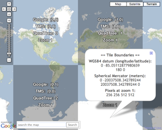
Google Maps Coordinates, Tile Bounds, ProjectionWe have just released a new online tool which could be an excellent starting point for people who are interested in publishing raster maps as tiles and are already familiar a bit with Google Maps API. This tool can help you to understand how the tiling using Spherical Mercator works in Google Maps, Virtual Earth, Yahoo Maps, OpenStreeMap and other services. It shows you how the tiles are referenced and how they are stitched together in the web browser. It is part of MapTiler documentation.

It also contains all the math you might need to overlay your own geodata from external sources be it tiles pre-generated by Maptiler/GDAL2Tiles, MSR MapCruncher, tiles generated dynamically by WMS servers and cached by TileCache etc.

The online tool visualizing the tiles is available here:


BTW Some old maps were published with the beta version of the MapTiler/GDAL2Tiles already. Have a look at Historical Map Overlays from National Library of Scotland: http://geo.nls.uk/maps/.

Monday, October 27, 2008

MapAnalyst Online: Accuracy of old maps

MapAnalyst is a software for the accurate analysis of old maps. Its main purpose is to compute distortion grids and other types of visualizations that illustrate the geometrical accuracy and distortion of historical maps.

The software uses pairs of control points on an old map and on a new reference map. The control points are used to construct distortion grids, vectors of displacement, accuracy circles, and isolines of local scale and rotation. As a by-product, MapAnalyst also computes the old map's scale, rotation and statistical indicators.


Bernhard Jenny from ETH Zurich, author of this tool, is working with us on an online interface for the generation of the accuracy visualizations. Our online georeference tool will give excellent base for this functionality, because we will have there already a database of Ground Contol Points, which we use to reference the maps and to generate metadata. We would like to use those GCPs also to generate visualizations a la MapAnalyst directly from the webbrowser.

Right now we just have simple prototypes and a lot of work in front of us. But in the end, as soon as you specify the control points for your map, you will be able to get a visualization similar to the one you see in this blog post just by one click of a mouse. The visualization will appear directly over the web presentation of your map. There will also be a possibility to download a high quality print-ready version (probably in SVG format).

The prototypes of the accuracy analysis online visualization of an old map of Switzerland:
MapAnalyst Online: Raster Demo

We will be using GeoJSON vector format like in this prototype to display the visualization:
MapAnalyst Online: Vector Demo

MapAnalyst is an open-source project so the online version is going to be available as an open-source as well. We will post progress reports on this blog.